BIOMAT Consortium

 BIOMAT Institute for Advanced Studies of Biosystems


Conference Venue

Manaus, AM - Brazil

25th - 30th, November


Tutorials (25 - 26, November):  

Federal University of AmazonasUFAM    Eulálio Chaves Auditorium                               (General Rodrigo Octávio Jordão Ramos Avenue,  3000 - Coroado)


Technical Sessions (27 - 30, November):  

Northern University Centre - UNINORTE Randolpho de Souza Bittencourt Auditorium (Emílio Moreira Street, 601 - Downtown)


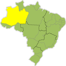
The State of Amazonas
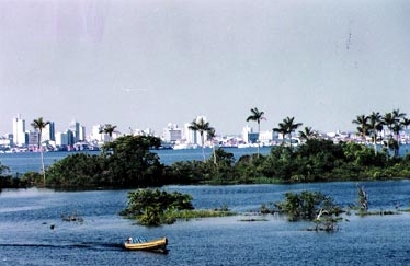
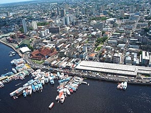
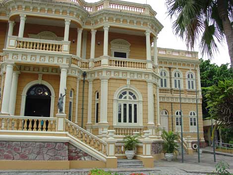
The largest state in Brazil, divided by waters and by the Rainforest, the State of Amazonas is a place of beautiful landscapes, unique and fixed contradictions. The cities raised in the middle of the jungle because of the technology (Zona Franca de Manaus), and thanks to the traditional habits of the local people, known as "caboclos". The explorer responsible for the discovery of the region was a spanish, named Francisco Orellana, in an expedition which started in 1541. Here and at that time, the Spanish found a rich native culture, which continues in the local popular minds.

Capital: Manaus

Population: 2,812,557 inhabitants (2000)

Area: 1,577,820,2 km²

Population Density: 1.31 inhab/km²

Latitude: Northernmost point - 2º08'30" and Southernmost point - 9º49'00"

Longitude: Easternmost point - 56º04'50" and Westernmost point - 73º48'46"

Municipalities: 62 (1997)


Time Difference: 4 hours behind Greenwich time, and 1 hour behind the rest of the Brazilian states, except for Acre which is 1 hour ahead.

Climate: Equatorial (hot and humid). Average temperature 89.6º F. The rainy season runs from December through June (it rains almost every day). The rest of the year is the dry season with intense sun and temperatures around 100.4º F. September temperatures can climb to around 104º F. Short but heavy showers are frequent.

Geographical Location: Located in the centre of Brazil's Northern Region, bordered to the North by the State of Roraima, Venezuela and Colombia; to the East by the State of Pará; to the Southeast by the State of Mato Grosso; to the South bye the State of Rondônia and to the Southwest by the State of Acre and by Peru.

Hidrography: Forms the largest water basin in the world with 6,217,220 km². Its main rivers are the Amazon, the Negro, the Solimões, the Juruá and the Madeira.

Relief: Characterized by dry land wich is very flat and low level. The higher ground, largely made up of the Itapirapecó, Imeri, Urucuzeiro and Cupim ranges, is on the border with the State of Roraima and with Venezuela. This is where Pico da Neblina (3,014m), Brazil's highest point, is located.

The Amazonian Plain is made up of: Floodplains, locally known as Várzeas (swamp forest flooded by blackwater rivers for extended periods) and Igapós (flooded forest flooded by seasonal whitewater rivers); and Dry Land.

Vegetation: Vegetation is dense, heterogeneous and deep green in colour. It covers 90% of the area's surface.

Types of forests in the region:

Perenifólia Hileiana Amazônica Forest (dry land forest);

Perenifólia Paludosa Ribeirinha Forest - flooded during seasonal periods (várzea forest); and

Igapó Forest - permanently flooded.


The tourist that visits the Amazon has the opportunity to acknowledge Tropical Forest's mysteries, being able to enjoy the comfort of trained guides or the possibility of perform, by him/herself, the "Jungle Survival Specialization Course", which is furnished by The Brazilian Army.

The junglehotels are enterprises built in the forests or in the river's borders. In addition, they could be floating lodges on the Amazon lakes. Two types of structures are found, lodges (resorts) and small bungalows.

There are many superlatives on the touristics attractions, such as the largest river archipelago in the world, Anavilhanas, which is located on the Negro river and it is formed by approximately 400 islands. Brazilian Federal Laws protects this area, which has about 350.000 hectares.

The Anavilhanas region is located in the vicinity of the "Jaú National Park", the largest forest reservation in South America. It has about 2.27 milion hectares, also marshed by Negro river. There are abundant fauna, flora and animals, some of which are almost extinct, such as manatee and giant river otter.

The Mamirauá Sustainable Development Reservation is the habitat of many curious mammals and exists like an ecological station since 1990. It has more than 300 fish species, including ornamental fishes, about 400 species of birds and some 45 species of mammals. One of the most strange mammals is the Uacari-branco (Cacajao calvus), a monkey, which weighs about 4 kg and eats immature fruit seeds.

Neblina Peak, the highest peak in Brazil, is located in the habitat of the most expressive Brazilian Amerindian tribe, the Yanomamis.

The Meeting of the Waters is a phenomenon that happens approximately 6 miles downstream from Manaus, where the Negro river's black waters and the Solimões river's brown, silty waters meet. They run side by side for about 6 km and never mix their waters. Below this point they form The Amazon River extending up to its mouth in the Atlantic Ocean. A nature's fancy very appreciated by tourists. Unique water conditions such as density, temperature and speed explain this phenomenon.

---------------------------


The City of Manaus

Manaus was founded in 1669, at the site originally known as Lugar da Barra (where the city lies today). In 1832 it was elevated to the category of village under the name Nossa Senhora da Conceição da Barra do Rio Negro. It turned into a city in 1848. It became the capital after Amazonas territory was elevated to the category of province, which happened in 1850.

The rubber boom brought progress to Manaus
. It attracted immigrants from all over the northeast part of the country as well as foreigners with the cycle of splendor and the construction of great historical buildings was initiated such as the Amazon Opera House, the floating docks, the pier, The Custom House and Adolpho Lisboa Market.


With the end of the rubber golden age in 1910, luxe and progress gave room to poverty. It was only after the creation of the Free Zone in 1967 that an industrial revolution started in the middle of the jungle creating a new cycle that brought back the splendor and all the gifts of modern life.


Population: 1,592,555 inhabitants (2004)

Urban area: 11,401 km²

Location: The urban area of Manaus is located between the coordinates 2º'57 and 3º10' South latitude and 59º53' and 60º07' West longitude.

Borders: Bordered to the North by the Municipality of Presidente Figueiredo; to the South by the Municipalities of Careiro and Iranduba; to the East by the Municipality of Rio Preto da Eva and Amatari; and to the West by the Municipality of Novo Airão.

Altitude: 25m above sea level.

Climate and Temperature: Humid equatorial.

Average Temperature: 80.06°F

Humidity: 80%

There are only two seasons in the state:

- The Rainy Season, correspondingin to winter, begins in December and lasts until May. It rain almost every day.
- The Dry Season, when it rains less, corresponds to summer and runs from June to November. September is the most critical month the temperature can soar 104°F.

Business and Shopping: Downtown businesses are open from 8am to 12pm and from 2pm to 6pm, Monday to Friday and from 8am to 12pm on Saturdays. However, there are many shops that now offer extended hours. Shopping Centres are open every day of the week and close at 10pm.

Banks: Open from 9am to 3pm.

Voltage: 110 volts (some hotels use 220 volts).

International Calls: '00' + Dial  Carrier Code + country + city code + number

Carrier Codes: Embratel (21)
                             Telemar (31)
                             Intelig (23)

Exchange Rate: Brazilian's official currency is the Real (R$). The exchange rate is around 1 US$ (dollar) to  R$ 2.12 (reais) and 1€ (euro) to R$ 2,62 (reais). Money can be exchanged at banks, exchange houses and at the International Airport Eduardo Gomes.

For more touristic informations, visit Manaus Online, AmazonasTur or Brazil Tourism Office.


From Manaus Online and Amazonas Convention & Visitors Bureau.


back


  updated on 14/11/06 20:41